Last Updated: 2nd Feb 2024
Hopeless
Submitted by Ben
Last Updated: 2nd Feb 2024
Open
Grunt Factor: 84 ?
Gnarl Factor: 57 ?
44.5km
2030m
2030m
2052m
Last Updated: 2nd Feb 2024
Submitted by Ben
Last Updated: 2nd Feb 2024
Open
Grunt Factor: 84 ?
Gnarl Factor: 57 ?
44.5km
2030m
2030m
2052m
Back country - remote
Loop
Mountainous
Native bush
Riverside
Lakeside
Open ridges/tops
Easy Single Track
Moderate Single Track
Technical Single Track
Untracked / Route only
Average Uphill Gradient: +10.8%
Average Downhill Gradient: -10.1%
Login as a VIP to see the trailhead information.
14:00
Slow
10:00
Moderate
7:00
Fast
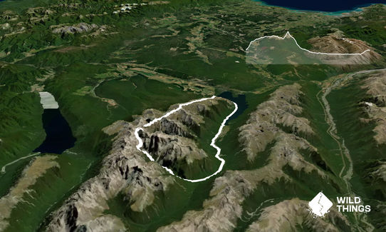
You start heading up the Pinchgut track where Robert Ridge is soon reached and the amazing views which you will get for the next few hours of Nelson lakes and across to Kahaurangi. Robert Ridge is a marked track which undulates slowly upward for about 11km, getting rougher and more technical as you head towards Angelus hut.
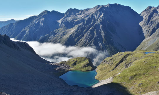
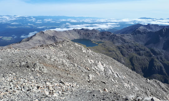
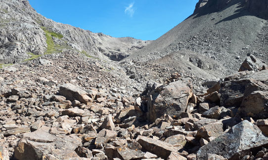
From Angelus hut to Hopeless there are no more track markers. Head in a south west direction crossing Lake Angelus outlet creek. Soon after this you will see Hinapouri Tarns which can be sidled on either side. Once past the tarns head up to the obvious saddle on the ridge line. Once on the saddle it is definitely worth doing the short side trip up to the top of Angelus peak - this is quite a steep scree scramble to the top. Once back at the saddle head south into Hopeless Creek, the terrain here is quite rough with a few km of shattered rock of varying size.
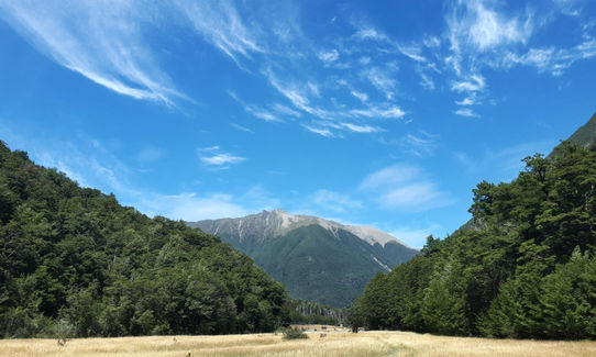
Once down in Hopeless Creek you will reach 2 larger tarns - after passing the second tarn sidle across on to the true right of the valley where you stay high to get around a large waterfall. Stay high until you get on to a large scree slope which provides easy access back down to the creek. Once at the creek it is only about 1km to the hut. From Hopeless hut it is an easy descent through native beach forest to the Traverse Valley. Head down the valley to Coldwater hut, then around the western side of the lake. Towards the end of the lake the track starts climbing back up away from the lake - take the Paddy's track at the junction which climbs steeply then heads across to the road and the car park.
This trail includes the peaks Angelus Peak, Mount Robert and Julius Summit.
Amazing views across Nelson Lakes, Richmond Ranges and Kahurangi.
Take the sign for Mt Robert / West Bay. Head past the lake cross the bridge and keep heading up to the top car park.
7 km
15 minutes
Unknown
No
Hard.
It is easy to find your way when there is good visibility, but the weather can change quickly and if the cloud rolls in being able to use a map and compass will get you home.
Unknown.
Waterproof leggings, Thermal leggings, Lightweight fleece top, Short-sleeved thermal top, Long-sleeved thermal top, Seam-sealed waterproof jacket, Gloves, Beanie/thermal headwear, Personal Locator Beacon (PLB), Whistle, First aid kit, Extra food for emergencies, Survival bag, Cellphone, Compass, Map, Headtorch and spare batteries, Crampons / microspikes (for winter conditions)
I drink the water out of the smaller rivers and streams and have not had any issues, the choice is up to you ! !
Definitely not a winter running trip, hopeless creak would become very difficult to navigate with only a small amount of snow on the ground
Lots of loose rock
Fastest Known Times (FKTs)
You and Hopeless
As a VIP member you can record private notes for this trail, see all of your times and more.
Already have an account? Login now
A Full moon then sunrise on Mr Robert ridge. Just stunning!!! but agreed anticlockwise might be the harder direction and the nail in the (well mine) coffin is the final climb from lake to carpark!
March 7, 2023
I'm pretty shit it at spotting cairns, coming up hopeless valley was a mission. great day.
January 8, 2023
Superb long run, agree with Massimo that I will go clockwise next time - do the easy kms first and finish on a downhill. Also, navigation would be a bit easier coming up from Hopeless Hut to Sunset saddle than down the first time you do it.
February 11, 2022
Perfect great day on the track. Set off an hour before dawn to enjoy the colors, clouds and light as the sun rises. I would also consider to run it clockwise in order to have an easier start and finish. Maybe next time!
March 22, 2021
These overlap with this trail to some degree. You may wish to combine them but please note that to qualify for FKTs on these runs you should record a separate activity for each.
The Wild Things Trail Directory is proudly supported by 
Send to your phone
Scan the below QR code to open this trail on your phone.

Tip: position the QR code in your phone camera screen.


