Last Updated: 1st Nov 2023
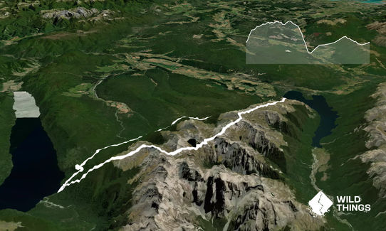
Angelus Mega Loop
Submitted by Mal Law
Last Updated: 1st Nov 2023
Open
Grunt Factor: 79 ?
Gnarl Factor: 67 ?
38.5km
1950m
1850m
1800m
.jpg?tr=w-542,h-325)
.jpg?tr=w-542,h-325)

Last Updated: 1st Nov 2023
Submitted by Mal Law
Last Updated: 1st Nov 2023
Open
Grunt Factor: 79 ?
Gnarl Factor: 67 ?
38.5km
1950m
1850m
1800m
Back country - remote
Loop
Mountainous
Native bush
Open ridges/tops
Easy Single Track
Moderate Single Track
Technical Single Track
Untracked / Route only
Average Uphill Gradient: +10.7%
Average Downhill Gradient: -13.6%
Login as a VIP to see the trailhead information.
12:00
Slow
9:00
Moderate
6:00
Fast
From the car park pick up the Pinchgut Track. This well made trail winds its way uphill through a series of zigzags to climb some 550m over just 3 kms. Initially it is all in bush but shortly before reaching Mt. Robert (a fairly indistinct summit off the track to the left) it breaks into the open revealing stunning 360 deg views.
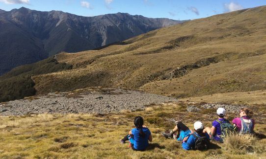
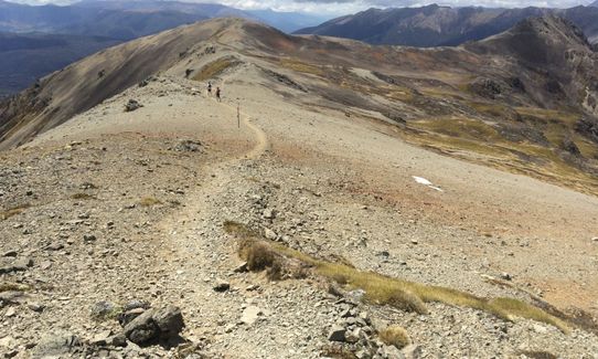
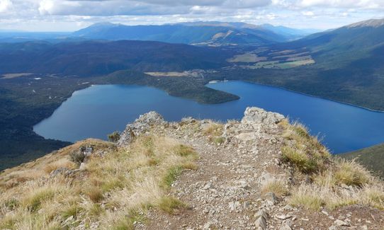
Follow the marker poles along the main ridge (ignore the left turn on to Paddys Track for Bushline Hut.) At first the ridge is broad and the trail is fairly mellow, but further along the ridge (beyond Flagtop) it gets a lot more technical with a lot of loose rock to traverse. But the views on a nice day - and you don't want to be doing this route on any other kind of day - are magnificent.
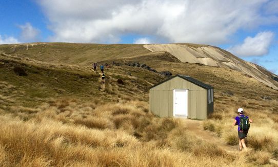
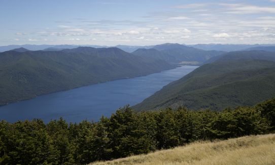
Eventually you'll drop off the southern end of the ridge to Lake Angelus and its huge new DoC hut (the first water on the trail.)
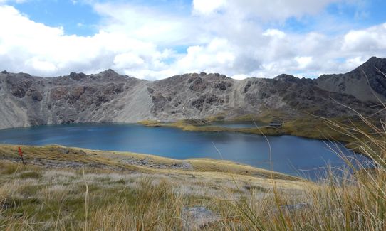
Beyond the hut follow the poled route towards Mt. Cedric, which is again quite technical in places.
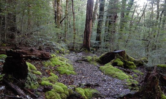
The route traverses just beneath the summit of Cedric and descends steeply into the bush en route to Sabine Hut. Your quads are now in for a trashing as the trail just keeps getting steeper the lower you get (a total descent of some 1100m over about 3k!)
At Sabine Hut turn right and soon afterwards right again on to Speargrass Track. Over the next 10k of bush travel you will climb gradually to reach Speargrass Hut. Beyond the hut the trail ducks and dives along Speargrass Creek and its many side streams, dropping a couple of hundred metres over about 5k, before a final unwanted climb over the last couple of kms to return to the Mt Robert car park.
This trail includes the peaks Mount Robert and Julius Summit.
Stunning ridge running all along the Robert Ridge.
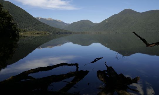
Lake Angelus is a classic alpine lake.
Plenty of parking, toilet, information board & map
7 km
12 minutes
Unknown
No
Hard.
The Robert Ridge and Cedric Route are poled routes only and although the trail is obvious enough in good weather it can be tricky in poor visibility. A map and compass, and the know-how to use them, are essential. If anything other than experienced in back country travel do NOT attempt this route without checking the forecast and satisfying yourself that there is a clear spell ahead.
Patchy.
Thermal leggings, Lightweight fleece top, Long-sleeved thermal top, Seam-sealed waterproof jacket, Gloves, Beanie/thermal headwear, Personal Locator Beacon (PLB), Whistle, First aid kit, Extra food for emergencies, Survival bag, Cellphone, Compass, Map, Headtorch and spare batteries, Crampons / microspikes (for winter conditions)
There is no water until you reach Angelus Hut (2-4 hrs depending on ability) and after that the next reliable water is at Sabine Hut. There are plenty of side streams along the Speargrass Track (and at Speargrass Hut) for the second half long bush section.
The tops are very exposed and can be lethal in bad weather. This is not a winter route and snow can linger well into the late spring. The bush sections - descending to Sabine Hut & the Speargrass Track can be horrendously muddy after heavy rain.
The main hazard is exposure on the tops. Go prepared with plenty of warm gear and extra food.
Wasps can be a menace in the bush, particularly on the Speargrass Track
Alpine Lodge
St. Arnaud
http://www.alpinelodge.co.nz
Great hospitality, great food and convivial atmosphere in their restaurant/bar
Fastest Known Times (FKTs)
You and Angelus Mega Loop
As a VIP member you can record private notes for this trail, see all of your times and more.
Already have an account? Login now
Did this anticlockwise, in perfect weather, over 2 days (training with a full pack for a 10 day trip). Amazing views and a solid climb out of Sabine....with plenty of rocks to slow you down on the ridge. Which lead to me being even more impressed by the FKT.
Practicalities - plenty of water on Speargrass but make sure you have water and sunscreen (I have a one-sided tan this week) leaving Sabine Hut and Angelus Hut. Don't think about this route in wind/bad weather.
February 3, 2022
AH
Did it in reverse also as same reasons as the other comments. Really stunning trail. Found the track along the ridge tedious after a while as a lot is rock hopping/scrambling which for me wasn't super fun. The views made up for it.
March 10, 2021
Also did it anticlockwise to enjoy the downhill along the ridge. Plenty of tree roots to negotiate along the bottom trails with some short faster sections. Brutal climb up Cedrics track (900m in 3km to the bushline) had me sitting and pondering my life choices a few times. Lake Angelus is beautiful as are the views along the ridge.
January 17, 2020
Did this except anticlockwise December 2018: Pros of doing it this way are you end on a highlight with an incredible downhill for the last 6 km or so, and you can't really run down from Cedric to the lake anyway (well I can't), it's too steep and technical. Cons are you have the small matter of a 1350m climb up from the lake, and if the weather was bad on the ridge you'd have a long backtrack to get out. The Speargrass gets a bit tedious at times but the ridge is an incredible route on a fine day with 15 continuous km above the tree line!
October 5, 2019
These overlap with this trail to some degree. You may wish to combine them but please note that to qualify for FKTs on these runs you should record a separate activity for each.
The Wild Things Trail Directory is proudly supported by 
Send to your phone
Scan the below QR code to open this trail on your phone.

Tip: position the QR code in your phone camera screen.


